
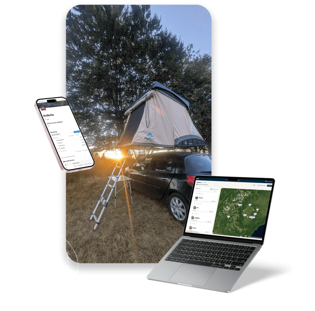
In this article, I share with you my way of’organising a road trip from the research phase to mapping, from structuring on Notion to real-time monitoring on Polarsteps. This is not a universal method. It's simply mine.
A organisation designed to optimise journeys, A balance between trekking, villages and culture, safe nights in a roof-tent... while retaining freedom to adapt once on the road.
If you enjoy preparing for a trip as much as experiencing it, you should recognise yourself.
The tools I use to organise my road trips
Here are the tools I use (most of which I mention in the rest of the article) to prepare, optimise and experience our roof-tent or motorbike road trips:
- Polarsteps You can programme and follow your route in real time, add photos and keep a precise record of stages and kilometres.
- Google Maps check actual distances and journey times, record locations and adjust the route to suit the terrain.
- Notion The road trip: centralising all the organisation of the road trip (day-by-day planning, budget, checklist, bookings, good addresses).
- Nuggets from France Check out the must-sees in a region and discover additional points of interest in France.
- Geocaching Find caches around you to discover unusual places, viewpoints and local anecdotes.
- Park4Night Finding places to sleep in a roof tent or van and securing an area for the night.
- FreeTaps locating drinking water points to top up reserves during the road trip.
Research points of interest in the roadtrip area
The very first thing I do when I'm planning a road trip isn't open Google Maps. It's to open... just Google.
I always start by doing my research. Tourist offices, travel blogs, accounts of experiences, sometimes even forums where someone says they've found “the incredible spot at the end of a piste”. I read, I browse, I compare. Not to find a turnkey itinerary. I'm not interested in that.
What I'm looking for is material.
Ideas for walks and villages well worth a visit, The aim is to identify what's worth stopping off for and what, quite frankly, is more a question of marketing the area. The aim is to identify what's worth stopping off for and what, quite frankly, is more territorial marketing.
I systematically keep the links to the content I consult. This allows me to build up a coherent resource base. I then inject them into ChatGPT to create a sort of “personalised database” based solely on what I've selected myself.
The idea is not to delegate thinking, but to use the tool to cross-referencing information. See what comes up often. Identifying the essentials. Detect inconsistencies. Identify alternatives.
And above all: filtering.
Because a successful road trip isn't just a series of activities. It's about a balance of nature walks, village discoveries and cultural breaks, and unexpected moments. It also means avoiding taking the same route three times or increasing the number of unnecessary round trips.
This first stage is a bit like the “broad exploration” phase. We open up the field of possibilities before starting to structure.
And that's precisely what allows us to build an itinerary that's truly our own. And during this phase, I already feel like I'm travelling, soaking up all this reading! 😍
Building the map and choosing the places to visit on the roadtrip
Once I'd identified the towns, villages and spots that came up regularly in my research, I moved on to the visual stage.
I work a lot with maps. As long as I can't see the route, it's hard for me to feel whether a route makes sense or not (no pun intended 🤪). So I use Polarsteps to create a new road trip and place the various stopping points.
But unlike in the previous phase, I no longer put down “everything”.
At this stage, I'm already starting to sort things out. I select only the points of interest that really stand out in my reading. Those that appear in several guides. Those that seem unmissable. Those that correspond to our way of travelling: nature walks, villages with character, cultural discoveries such as caves or castles.
The idea is no longer to explore widely. It's about structuring.
By placing these points on the map, I can immediately see if something is wrong. Too big a diversion. An unnecessary loop. Two stages that could be grouped together on the same day. Sometimes, a place that I thought would be “nearby” turns out to be completely out of the way.
This is where the optimisation really begins.
I move, regroup and delete. I look for a fluid geographical logic to avoid unnecessary return trips. If a stage can be done as a simple stop on the route rather than as a dedicated excursion, I integrate it differently.
A good road trip isn't just an accumulation of points on a map. It's a coherent route where every move makes sense.
And this is precisely the stage that allows me to transform a wish list into a realistic and optimised itinerary.
Using AI to design your roadtrip
During this mapping stage, I don't just place points on Polarsteps.
I'm also asking ChatGPT to help me structure everything I've collected.
In practical terms, I provide him with the links and information I've found and ask him to extract the main points of interest. Then, I generate clear tables with, for each place: the town, an estimate of distances, and above all a categorisation (charming village, hiking stop, natural site, cultural visit, etc.).
This classification changes everything.
Instead of having a mass of information that's a bit fuzzy, I end up with a readable data set. I can see straight away if I have too many hikes in a day, not enough “village” breaks, or on the contrary too many cultural visits in a row. It helps me to balance things out.
And above all, it allows me to place on the map only points that have already been sorted and prioritised.
An important aside: ChatGPT is a help tool, not an infallible GPS. When it comes to estimating distances and optimising journeys, it has clearly improved. But it's not perfect.
I always check the kilometres and journey times on a dedicated mapping tool (Polarstep has one) before approving anything. To trust blindly would be a mistake.
The idea is not to delegate thinking and design, but to gain clarity.
Estimating stopover times and scheduling overnight stays
Once I've placed my points of interest on the map and have a clear categorisation between villages, walks and cultural visits, I move on to a key stage: time.
Because an optimised route on the map means nothing if, on the ground, the days are unrealistic.
So I start estimating how long each stop will take. A hike isn't just “a point on the map”. It's a long walk, a change in altitude, a break at the top, sometimes a slightly longer access than planned. A visit to a village, depending on its size and interest, can take an hour or half a day. A cave or a castle imposes precise timetables.
At this stage, I'm not looking for up-to-the-minute precision. I'm looking for consistency.
And above all, this is when I start thinking about nights in a roof tent.
Each day must naturally lead to a logical place to sleep. There's no question of ending up at 7.30pm with another 1h30 drive to reach a spot. Ideally, a major point of interest should correspond to the area where you plan to spend the night.
Sometimes it's the day's highlight hike that determines the bivouac. Sometimes it's a village where you want to enjoy the evening light. Sometimes it's simply a geographically strategic area where you can set off again the next day without unnecessary detours.
That's when the road trip becomes a reality.
We're no longer just talking about places. We're talking about rhythm.
And in a rooftop tent, rhythm is essential. Too crowded and you'll be overwhelmed. Too empty and you get bored. This is where the balance lies.
Find a place to sleep in a roof tent
In the beginning, I did things well.
I found specific spots in advance on Google Maps and Park4Night. I saved links, created favourites and wrote down the exact coordinates. The idea was simple: on the big day, you arrive in the area, click on the link and set down.
On paper, it was perfect... In practice... it very rarely worked as planned.
Sometimes Google Maps can be misleading. A path that seemed accessible wasn't really. A corner that looked isolated wasn't really isolated at all. Other times, the spot you found was simply not optimal for the pace of the day.
Because the truth is that roadtrips are alive and well.
You can plan ahead, but the weather changes, a hike takes longer than expected, a village holds you back longer, or on the contrary, you move forward more quickly. The result is that the “perfect” location planned weeks before no longer suits the dynamics of the moment.
Today, I work differently.
I keep to a guideline. I know overall in which zone we should finish the day. But I no longer choose a specific spot in advance.
In practice, it's often at lunchtime or during a break in the afternoon that we open Park4Night to look at the options around the area where we are or where we plan to end the day. It's the actual rhythm that determines the bivouac, not the theoretical schedule.
On the other hand, I always check one important point upstream: in the area planned for the end of the day, are there any spots referenced on the application?
If there are none, this is often a sign. Either the area is complicated, highly regulated or simply unsuitable for pitching a roof-tent. In this case, I adjust the itinerary to make sure there's at least an emergency solution not too far away.
The aim is no longer to lock in a precise point months in advance.
The aim is to secure an area.
Find French nuggets to discover even more beautiful things
At this stage, the route is really starting to take shape.
The main stages are laid out, the days are logical, the nights are consistent and the distances are realistic. In short, the roadtrip is taking shape in earnest.
That's when I use Nuggets from France to carry out a strategic audit.
The idea is not to call everything into question. It's more of a quality control.
I check whether the places I've already selected correspond to the “nuggets” listed in the zone. Are my must-sees listed correctly? Is there a remarkable site that I haven't seen? A natural curiosity, a viewpoint, a listed village, a historic site?
In most cases, as my initial research phase was fairly thorough, most of the points of interest are already included in the itinerary. But sometimes an extra nugget is clearly worth a diversion... as long as it fits in with the timing.
And therein lies the nuance: I never add a point just because it's well noted. It has to fit naturally into the geographical logic and the planned rhythm.
Another advantage: I'll be using the app during my road trip too. It allows me to’quick access to GPS points and practical information once we're there. So, as for the rest, I'm bookmarking the nuggets in the areas we'll be visiting.
The aim is not to overload the programme.
It's about refining.
Centralise the organisation of the roadtrip in an operational document
Once the itinerary is built, optimised and coherent, I move on to what I consider to be the most strategic stage: drawing it up.
With Polarsteps, I already have the GPS points, the main stages and an overall view of the route. But Polarsteps is mainly used for mapping and tracking. It's not where I structure the day's route in detail.
I use Notion for this.
I have a template dedicated to road trips. It's a complete file that brings everything together.
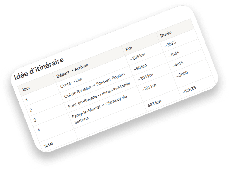
First, a day-by-day summary table with :
- the major stages planned,
- approximate kilometres,
- and an overview of progress.
The kilometres aren't just for the organisation. It's also for my personal statistics. I like to know how much we plan to ride, how the journey was divided up, and to analyse afterwards whether certain days were too busy.
Then, for each day, I have a detailed insert.
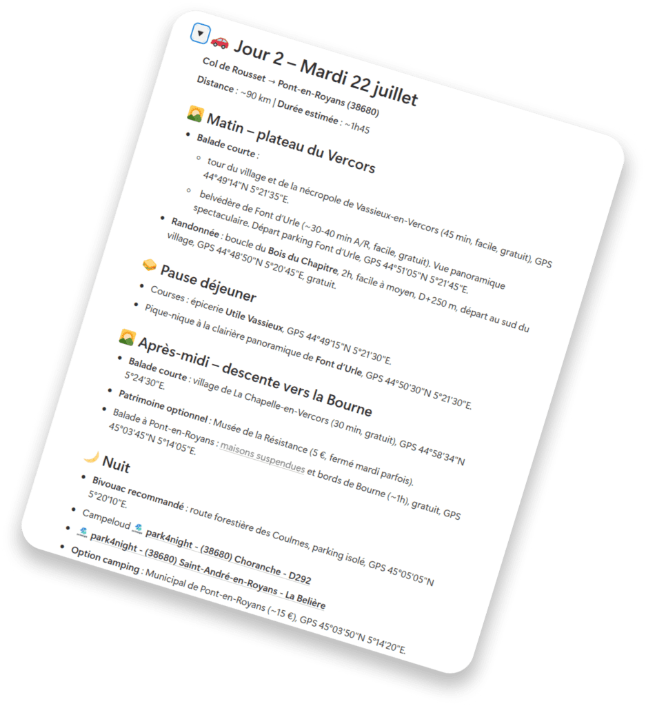
In particular, I note:
- planned points of interest,
- booking links if necessary,
- any timetables,
- good addresses identified in advance.
The idea is simple: when the time comes, I click. I don't search. I don't waste time finding a site or an activity on Google.
But the Notion sheet isn't just for planning.
It also contains :
- a checklist of things to pack, with boxes to tick,
- and the budget monitoring table.
Every day, I keep track of expenses by category: food, petrol, tolls, activities, etc. Accommodation is rarely a major item in a tent, but everything else is monitored.
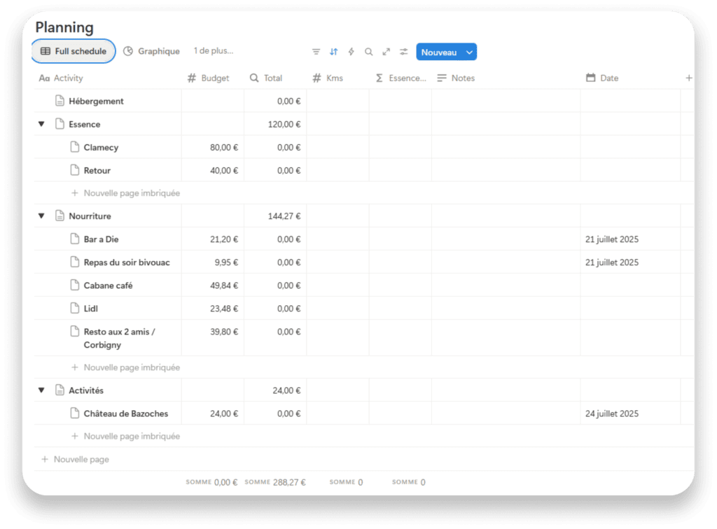
At the end of the road trip, I have a clear picture. I know how much it cost, and which item was the most important. Spoiler: it's almost always the food.
And if I do things right, I also make a note of the places where we ate. This way, when I'm writing the article or planning a future visit to the region, I have a reliable memory of the good places we discovered along the way.
During the road trip: follow, adjust, enjoy
Once on the road, everything that has been prepared beforehand becomes a basis.
But it's no longer a fixed plan. It's a flexible framework.
Polarsteps for tracking and tracing
During the road trip, Polarsteps automatically follows our route.
Photos are added directly to the stop-off points, so our friends and family can follow the adventure almost live. But above and beyond the sharing, it's above all an extremely valuable record.
Afterwards, we know exactly :
- where we were,
- on what date,
- how many kilometres we've travelled,
- and which stops really marked the route.
It's a reliable memory of the journey.
Exploring beyond the programme
Once you have reached a point of interest, the programme can change.
Were we planning to visit a village? That's fine. We wander. Explore. Take your time.
But sometimes it's smaller than expected. Faster. Or on the contrary, you want to go further. Or a local has made a recommendation, ...
At this point, we check a number of things:
- Is there a nugget listed on Les Pépites de France nearby?
- Are there any geocaches in the area via Geocaching?
- Is there a viewpoint, a natural site or an interesting historical detail that has not been included?
We've been doing geocaching for several years now. It's a bit like our own personal treasure hunt. We don't always find what we're looking for, but very often it takes us to places that aren't indicated in the guidebooks: a hidden viewpoint, a historical curiosity, a local anecdote.
Sometimes a simple hideaway tells us that a particular stone, wall or corner of the village has a special history. These are details we would never have discovered otherwise. (And it's free! or just the cost of an annual subscription to the app if you want to see all the caches).
Adjust nights to suit actual rhythm
After lunch or in the afternoon, we usually start thinking about where to sleep.
You open Park4Night and look at the options around the area you're in or heading towards. And here again, everything can change. If a village was quicker than expected, you can move on to the next stage. If a hike has taken us longer, we stay in the area. The night can be moved. The road trip can be shifted by a day without it being a problem.
The idea is not to set things in stone.
It's about having a direction... and then letting it carry you along.
Managing food in the moment
For meals, it depends.
Sometimes I've already spotted some interesting restaurants and I know that it will make sense to go there at a particular time during my stay. In that case, we follow the plan.
Otherwise, it's more spontaneous: little shopping trips for a picnic, especially on hiking days, or decisions made on the spur of the moment depending on where you are.
Nothing is rigid. Everything adapts. In any case, we have non-perishable foodstuffs (tinned Catalan-style tuna, crisps, instant noodles, dry cakes, etc.) in the car.
A synchronised organisation
All the work prepared on the computer (Notion, markers, favourites) is synchronised on the phone.
So even if the schedule changes, we still have access to :
- to GPS points,
- to bookings,
- to the right addresses,
- to the nuggets recorded,
- to the budget.
The framework is structured.
But the experience remains fluid.
Conclusion - Organise to let go
This approach to road trips is not for everyone. Some people prefer to set off without a plan, deciding at the last minute and improvising every stop. And to be honest, I totally understand this approach. Freestyle has its charm.
It's just that my pleasure starts long before I turn the ignition key.
The design phase is already part of the journey. Researching, comparing, mapping, optimising, structuring... it's a real thrill. It's already one foot in the holidays. It's already a mental projection of the roads we'll be taking, the villages we'll be passing through, the hikes we'll be doing.
Organising doesn't take away any of my freedom.
On the contrary, it reassures me enough to let myself be carried along.
As the road trips progressed, the tools became naturally intertwined: Polarsteps for the trace, Notion for the structure, Park4Night for the nights, Les Pépites de France to refine, Geocaching to explore in a different way.
This process evolves with each trip. It becomes more refined. Sometimes it becomes simpler. It always adapts.
If this organisation can help you plan your next road trip with greater peace of mind, then we've achieved our goal.
And if you want to follow our adventures in real time, or find the history of our road trips in front-page stories, join us on Instagram. We share the behind-the-scenes stories, the pitfalls, the unlikely spots... and everything else that doesn't always fit in the articles.